Today, I want to dive into a topic close to my heart: GIS mistakes. Throughout my journey in the GIS industry, I’ve encountered a myriad of challenges, and I’ve learned that making mistakes is not only common but also a crucial part of the learning process.
In this post, I’ll share the 10 most common GIS mistakes people make, drawing from my own experiences and observations. Whether you’re a seasoned GIS professional or just starting on your GIS journey, understanding these pitfalls can save you time, frustration, and even help you enhance your skills. So, let’s jump right in and explore the world of GIS blunders together.
What is an Error in GIS?
In the realm of Geographic Information Systems (GIS), an error refers to any deviation or discrepancy between the observed or recorded data and the true or expected values within a spatial dataset or analysis. Errors can manifest in various forms and can arise from a multitude of sources throughout the GIS workflow, from data acquisition and processing to analysis and interpretation.

Types of Errors in GIS
- Data Acquisition Errors
- Measurement Errors – These errors occur during the process of collecting spatial data, such as inaccuracies in GPS measurements or imprecise surveying techniques.
- Sampling Errors – When collecting data from a subset of a larger population, sampling errors can occur if the sample is not representative of the entire population, leading to biased results.
- Data Entry Errors – Mistakes made during manual data entry, such as typos, misinterpretations, or omissions, can introduce errors into GIS datasets.
- Data Processing Errors:
- Georeferencing Errors – Georeferencing involves aligning spatial data to a known coordinate system. Errors in georeferencing can result in misalignment or displacement of features within a map or dataset.
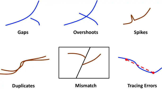
- Digitization Errors – Digitizing involves converting analog or paper maps into digital formats. Errors in digitization, such as oversimplification, underrepresentation, or misplacement of features, can distort the accuracy of spatial data.
- Interpolation Errors – Interpolation methods are used to estimate values between known data points. Interpolation errors can arise from assumptions about data continuity or inappropriate interpolation techniques.
- Data Analysis Errors:
- Statistical Errors – Statistical analysis in GIS involves quantifying spatial patterns, relationships, and trends. Errors in statistical analysis, such as incorrect model assumptions, sampling biases, or inappropriate statistical tests, can lead to erroneous conclusions.
- Modeling Errors – GIS models simulate real-world processes or phenomena. Errors in modeling can result from oversimplification, parameter uncertainty, or incomplete understanding of the underlying processes.
- Algorithmic Errors – GIS software employs algorithms to perform various spatial operations and analyses. Errors in algorithm design or implementation can produce incorrect results or outputs.
Sources of Errors in GIS
In this section, I will highlight some of the common sources of errors in GIS. The list can be long but I will focus on the ones below;
- Human Factors
- Human error, such as mistakes made during data collection, processing, or analysis, can introduce errors into GIS datasets. Lack of training, attention to detail, or adherence to standard procedures can exacerbate human-induced errors.
- Instrumentation and Technology
- Errors can occur due to limitations or inaccuracies in the instruments or technologies used for data acquisition, such as GPS receivers, remote sensing devices, or surveying equipment.
- Data Characteristics
- Inherent characteristics of spatial data, such as scale, resolution, accuracy, and precision, can influence the magnitude and nature of errors in GIS datasets. Low-quality or outdated data sources can exacerbate errors in GIS analyses.
We’ve understood about the types and sources of errors in GIS projects. Let’s now look at the common mistakes committed by GIS users (in general).
Common Mistakes in GIS
1. Not Defining Clear Objectives
Many of us have been a victim. Starting projects without clear and defined goals often leads to wasted time and resources. You may end up lost in a sea of data, unable to discern meaningful insights or make informed decisions.
To avoid this pitfall, it’s essential to set SMART objectives—Specific, Measurable, Achievable, Relevant, and Time-bound. By defining clear objectives from the outset; GIS users can focus their efforts and resources on tasks that align with their project goals, increasing the likelihood of success.

2. Poor Data Quality
Data is the lifeblood of any GIS project, and its quality can significantly impact the reliability and accuracy of analysis and decision-making. Unfortunately, many GIS users overlook the importance of data quality, leading to errors, biases, and misinterpretations in their results.
Common data quality issues include inaccuracies, inconsistencies, and outdated information. To mitigate these risks, GIS users must implement robust data quality assurance measures, including data validation, cleansing, and updating processes. By ensuring the integrity and reliability of their data, users can enhance the credibility and effectiveness of their GIS projects.
Today, there are many GIS data online repositories. Most of the datasets on some of these repositories require close attention to ensure data quality.
3. Neglecting Coordinate Systems and Projections
This topic is always confusing to many. Coordinate systems and map projections are foundational concepts in GIS, yet they are often overlooked or misunderstood by users. Using incorrect or mismatched coordinate systems can result in spatial distortions, misalignments, and inaccuracies in GIS analysis and visualization. I was a victim many times when starting.
To avoid this mistake, GIS users must familiarize themselves with different coordinate systems and projections and select the appropriate ones for their projects. By ensuring spatial data is correctly referenced and projected, users can maintain the accuracy and integrity of their GIS outputs.
4. Overlooking Metadata Management
Every GIS user has committed this mistake at least once. Do you create Metadata for your layers/data?
Metadata—the “data about the data”—plays a crucial role in GIS data management, facilitating the discovery, understanding, and use of spatial information. However, many GIS users neglect metadata management, leading to confusion, inefficiencies, and data loss.
To address this issue, users should prioritize the creation and maintenance of comprehensive metadata for their GIS datasets. By documenting essential information such as data source, quality, and usage restrictions, users can enhance the usability and accessibility of their GIS data, enabling informed decision-making and collaboration.
5. Ignoring Spatial Analysis Techniques
Spatial analysis is at the heart of GIS; enabling users to analyze, interpret, and visualize spatial patterns and relationships. Despite its importance, many GIS users underutilize spatial analysis techniques or apply inappropriate methods to their projects. Does this project require a buffer or clip? Do I require to perform interpolation? These are some questions users ask themselves often.
By expanding your toolkit of spatial analysis tools and techniques, you can unlock new insights and uncover hidden patterns in your spatial data. Whether it’s identifying hotspots of disease outbreaks, modeling urban growth, or assessing environmental impacts; spatial analysis empowers GIS users to derive actionable insights and inform evidence-based decisions.
6. Lack of Regular Backups and Version Control
Ever collected data in the fields and by evening you don’t have any data on your devices? Or even have incomplete or incorrect data? Many users have experienced this.
Data loss or corruption can be devastating for GIS projects, potentially leading to costly rework, delays, or even project failure. Yet, many GIS users fail to implement adequate backup and version control mechanisms, leaving their data vulnerable to unforeseen disasters or human errors.
To safeguard against data loss and ensure data integrity, users should establish regular backup routines and implement version control systems. By maintaining backup copies of their GIS datasets and tracking changes over time, users can restore lost data and track the evolution of their projects with confidence.
7. Poor Map Design and Visualization
Which tool do you use to create your maps?
Maps are powerful tools for communicating spatial information, but poor map design and visualization can obscure rather than illuminate insights. Cluttered layouts, inappropriate symbology, and misleading representations are common pitfalls that GIS users should avoid.
To create effective maps, users should adhere to principles of cartographic design, including simplicity, clarity, and visual hierarchy. By selecting appropriate colors, symbols, and labeling techniques, users can enhance the readability and interpretability of their maps, ensuring that they effectively convey their intended message to the audience.

8. Failure to Consider Privacy and Security Concerns
In an age of increasing data privacy and security concerns, GIS users must protect sensitive information and safeguard against unauthorized access or disclosure. Failure to implement adequate privacy and security measures can result in privacy breaches, data breaches, or legal liabilities. To address these concerns, GIS users should prioritize data encryption, access controls, and compliance with relevant privacy regulations. By adopting a proactive approach to privacy and security, users can build trust and confidence in their GIS systems and protect the privacy rights of individuals.
9. Insufficient Training and Skill Development
When was the last time you learnt a new skill? today? yesterday? last week? Which skill was it?
GIS technology is constantly evolving, and users must keep pace with new developments and best practices to maximize its potential. However, many GIS users lack sufficient training and skill development opportunities, leading to skills gaps and suboptimal use of GIS tools and techniques.
To address this challenge, organizations should invest in training programs, certifications, and professional development opportunities for GIS practitioners. By equipping users with the knowledge and skills they need to succeed, organizations can unleash the full power of GIS and drive innovation and excellence in spatial analysis and decision-making.
10. Lack of Collaboration and Communication
GIS projects often involve multidisciplinary teams with diverse expertise and perspectives. However, poor collaboration and communication can hinder the effectiveness of these teams, leading to data silos, misaligned goals, and missed opportunities. To foster collaboration and communication, organizations should implement tools and processes that facilitate knowledge-sharing, collaboration, and decision-making among team members. By breaking down silos and promoting transparency and openness, organizations can harness the collective intelligence of their teams and achieve better outcomes in their GIS projects.
In conclusion, GIS technology offers immense potential for unlocking insights, solving complex problems, and making informed decisions in various domains. However, to realize this potential, GIS users must be mindful of common mistakes that can derail their projects and undermine their efforts. By avoiding the 10 common GIS mistakes discussed in this article and embracing best practices and continuous learning, GIS users can harness the full power of GIS technology and drive positive change in their organizations and communities.


The 10 Most Common GIS Mistakes People Make